ROADSIDE REVEGETATION
An Integrated Approach to Establishing Native Plants and Pollinator Habitat
Learn
Through Cut Planting Pockets
| Location: | Tiller Trail Highway (Highway 227) 5 miles south of Tiller OR |
| Lat/Long: | N42o56'35.7", W123o00'53.1" |
| Dates Implemented: | Summer 2003 and Winter 2004 |
| Client: | Western Federal Lands Highway Division |
| Planners: | R6 Restoration Services Team |
| Contractors: | Greg Cary |
| Case Number: | 0004 |
| Date Submitted: | December 2008 |
| Focus Area: | Biotechnical Engineering, seedlings |
Background and Objectives
A large through cut was created in granitic bedrock during the construction of the Canyonville 5 Highway project. It was decided during the planning phase to establish trees and shrubs in localized areas to reduce the visual impacts of the large cut slopes. The designed called for carving out ledges to be filled in with growing media, then planted with seedlings. The resulting planting sites were named "planting pockets". The revegetation objective was that after 3 years there would be at least one live plant per pocket. There were multiple limiting site factors to establishing vegetation. The overriding limitation was the granitic bedrock exposed at the surface. It ranged from fresh (non-weathered) to decomposed, but generally lacked significant fracturing (sites for roots to access deeper moisture). The hot dry climate from May through September was another major consideration, especially on the south facing slope. The strong afternoon winds that blow upriver during the summer also create very stressful conditions for establishing plants. We would also learn that deer browse would be a major limiting factor. And from an operational standpoint, accessing the planting pockets on the steep (1:1) slopes would be a challenge, requiring climbing gear.
Implementation
Planting pockets were created as the through cut was being excavated. Most planting pockets were 2.5 feet wide by 10 to 12 feet long filled with compost to a depth of 12 to 15 inch depth. Compost originated from grounded cull seedlings (seedlings discarded during nursery processing operations) and possessed a high faction of sands.
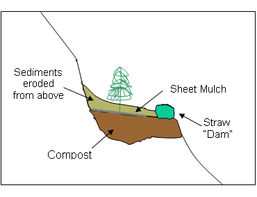
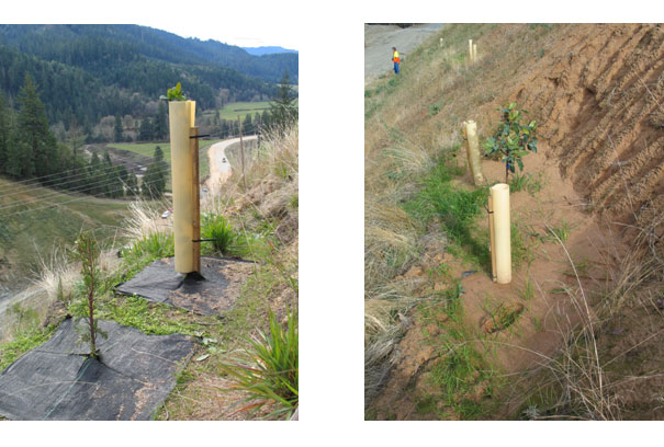
During the following winter, planting pockets were recontoured by mounding straw across the front of the planting pocket at a thickness of 4 to 6 inches (see figure). The intent was for sediments, originating from rainstorm, to collect behind the straw "dams" and deepen the rooting zone of each pocket. Pockets were planted with an assortment of native species: Douglas-fir, ponderosa pine, Oregon white oak, incense cedar, serviceberry, whiteleaf manzanita, chinquapin, Wood's rose, Pacific madrone, deerbrush, and Oregon grape. After planting, sheet mulch was installed around each seedling. Tree shelters were placed around many of the seedlings to reduce the effects of wind desiccation and deer browse. Planting took place over a three year period to account for the pockets where seedling mortality was high.
Findings
Survival monitoring in October 2007, four years after installation, showed that there were approximately 2.5 live plants per planting pocket. Growth was surprisingly good considering the harshness of the site (leader growth averaged 12 inches for ponderosa pine and heights ranged from 2 - 4 feet). One of the factors that might account for the better than expected survival is the capture of surface runoff by the planting pockets during summer rainstorms. Considering that the granitic bedrock of this site had little, if any, infiltration capabilities, the runoff from these storms into the pockets had to be very high, potentially recharging the soil moisture of the planting pockets during each rainstorm.
It remains to be seen if the long term goal of visually screening the through cut slopes was achieved with planting pockets; it is still questionable if plants will continue to grow at the current rates with so little soil to draw from.
Figures
Conceptual drawing of a planting pocket: the ledge was first filled with compost 12 to 15 inches deep, with a straw dam installed near the front. Sheet mulch was applied around the seedling to keep unwanted vegetation from competing with the seedling. The straw dam settled out sediments originating during rainstorms which increased the rooting depth of the pocket.
The photograph on the left shows a planting pocket with incense cedar (foreground) and madrone just growing out of the tree shelter. The photograph on the right shows a planting pocket in decomposed granitic bedrock after a rainstorm which deposited a large quantity of sediment from above.
Applicability
Planting pockets could have applicability to many roadside revegetation projects. However the design would have to match the topographic, climatic, and bedrock characteristics of the site. Generally the pockets should be redesigned for deeper soils (at least 2 feet deep), especially where the bedrock has very little fracturing or zones of weakness. Locating planting pockets where the bedrock is fractured could increase the long term establishment of trees and shrubs by increasing the depth of the rooting zone of the planting pocket.
Related Links
Technical Guide, 10.1.8 Topographic Enhancements
Contact Information
David Steinfeld, USDA Forest Service; 541-552-2912, dsteinfeld@fs.fed.us