ROADSIDE REVEGETATION
An Integrated Approach to Establishing Native Plants and Pollinator Habitat

3.4 Defining Revegetation Units
Revegetation units are areas with similar revegetation treatments and environment (e.g., soils, climate, and vegetation potential). In mountainous terrain, there may be several revegetation areas in a mile of roadside due to changes in aspect, soil type, and road drainage. Roads in mid-western states, however, often have only one revegetation unit that may encompass much of a project area because of the uniformity of the landscape. The first step in developing a revegetation unit is grouping major soil types together with similar characteristics important for reestablishing native plant communities. For example, a project site with a group of soils that are less than a foot deep would have a different set of revegetation treatments than deeper soils and for that reason would be identified as a revegetation unit based on soil depth. Grouping soils into revegetation units can also be done through the Ecological Sites section of the Web Soil Survey. As described in Figure 3-5, a soils map and report are created on the Web Soil Survey by delineating the project area on the interactive map of the U.S. At the same time, a map can also be produced that groups soils by similar capabilities to create distinct plant communities called "ecological sites". The ecological sites section of the Web Soil Survey also lists the major native species for each ecological site for many parts of the U.S.
Revegetation units also designate areas that have the same revegetation objective. For example, a road project may include a constructed wetland for maintaining or improving water quality. In another area, the objective may be to enhance pollinator habitat. These areas would be designated as separate revegetation units because they would have different revegetation treatments and species, which might include a pollinator species mix for the pollinator habitat unit and an erosion species mix for the wetland unit. In addition, soil improvement treatments for the wetland would be developed to enhance wetland species and maintain the proper functioning of a constructed wetland. This may include creating manufactured soil that is specific to wetland species and water filtration.
Road components also play a large role in delineating revegetation units. In mountainous terrain, cut slopes and fill slopes are often designated as separate revegetation units because of the differences in soil depth, slope gradient, and road drainage between the two slopes. Table 3-5 shows revegetation units commonly associated with the components of a road.
The revegetation plan includes a revegetation unit map that locates revegetation units on the road project map (Figure 3-8). The revegetation plan further describes the soils, climate, and vegetation of each revegetation unit and how the revegetation objectives will be met.
Table 3-5 | Common revegetation units often associated with road components
Road component |
Types of revegetation units |
Cut slopes |
Cutslopes, living snow fence, pollinator habitat |
Ditches |
Amended ditches, wetlands, biorention swales, bioswales |
Shoulders |
Shoulders |
Fill slopes |
Fill slopes, filter strips, amended fill slopes, wave-attenuating bioscreens, living snow fence, pollinator habitat |
Culvert outlets |
Vegetated culvert outlets |
Engineered slopes |
Reinforced soil slopes, vegetated MSE walls, bioengineered slopes |
Bridges |
Stream restoration terraces and slopes |
Disposal or staging areas |
Restored areas, pollinator habitat |
Abandoned roads |
Restored obliterated road, pollinator habitat |
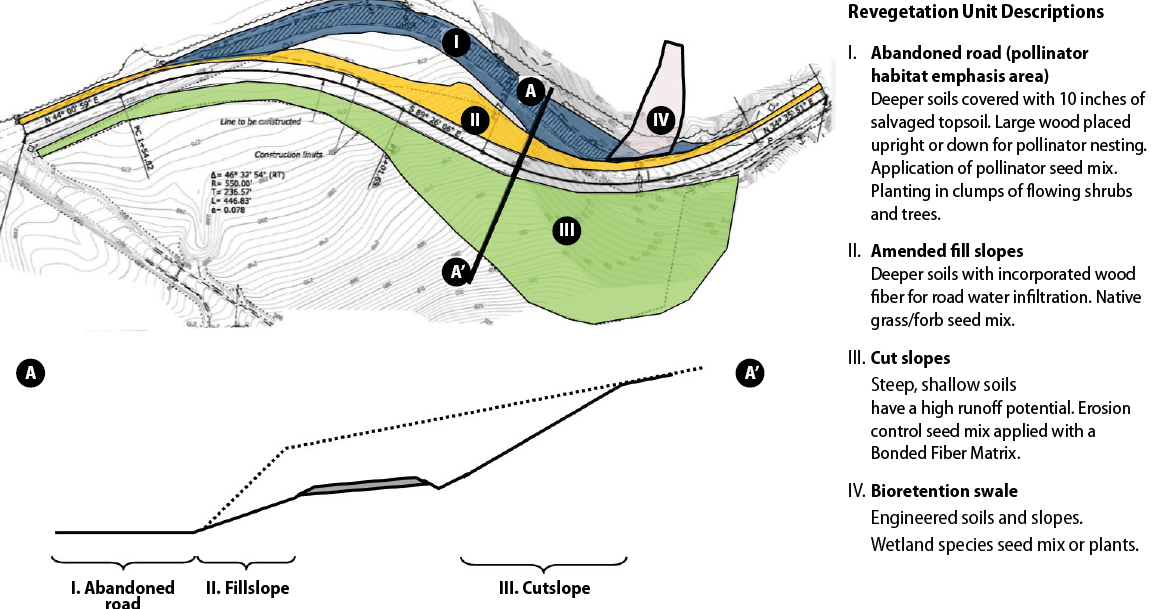
Figure 3-8 | Example—cut and fill slopes often define revegetation units
Major road components such as cut slopes, fill slopes and abandoned road sections often define revegetation units because of similar soils, objectives, and revegetation treatments. The road project in this example has four revegetation units that correspond to cut slopes, fill slopes, abandoned road, and bioretention swale. The objective for the road reconstruction project was to reduce existing curves for traffic safety while increasing pollinator habitat and decreasing the effects of road runoff and soil erosion on water quality. The road plans call for realigning the road, leaving an abandoned section of road, and greater area in cut slopes. During the planning phase, the revegetation units were identified based on soils and road objectives. Revegetation Unit I is the abandoned section of road to be restored by removing pavement, subsoiling the subbase, adding fill, and applying salvaged topsoil. Because the area is a pollinator habitat emphasis area, the seed mix will have more than 50 percent pollinator forb species. Flowering shrubs and trees will be planted in clumps. Salvaged logs from the road clearing operation will be randomly placed upright and on the ground for pollinator nesting habitat. Unit II includes fill slopes that will be amended with shredded wood to increase infiltration rates and capture and filtrate road surface runoff water. A low-growing native grass and forb seed mix will be applied. Unit III includes steep-cut slopes with high erosion potential that will be terraced and a seed mix primarily composed of grasses for erosion control will be applied in a bonded fiber matrix (BFM). Unit IV is a shallow draw where all road ditch water collects. It will be constructed as a bioretention swale to retain and filter sediments and road pollutants from the water before entering the stream. Wetland seedlings will be planted.