ROADSIDE REVEGETATION
An Integrated Approach to Establishing Native Plants and Pollinator Habitat

7.2 Decision Process for Treating Unwanted Vegetation
Most states have a decision-making process within the IVM for treating unwanted vegetation. The process includes some or all the steps outlined in Figure 7-1. An IVM decision-making process can be used to evaluate the control of an individual target weed species (e.g., noxious weed control) or control the vegetation on an entire section of roadside. In this process, roadsides are inventoried and objectives are set for unwanted vegetation. All methods for treating unwanted vegetation are considered, including no action, mowing, herbicide application, manual removal, prescribed burns, grazing, and biological control. A treatment plan is developed based on a thorough understanding of a species or plant community. Treatment plans often outline the "action threshold" or "tolerance level" that, when exceeded, constitutes the implementation of a vegetation treatment. The effectiveness of the treatment is determined based on monitoring. If the treatment is ineffective, then the treatment options are reviewed and updated, if appropriate. If the treatments are effective, then no action is taken and monitoring continues.
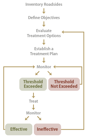
Figure 7-1 | Components of a decision-making process for treating unwanted vegetation
7.2.1 Inventory of Roadsides
Roadsides are inventoried for weeds or unwanted vegetation. For some states, invasive and noxious weeds are reported using GPS equipment and GIS mapping technology. The associated maps often prioritize sections of road that require some form of vegetation control. Roadside inventories can also show areas of desirable vegetation, rare plants, threatened species or populations, natural areas, pollinator habitat, and vegetative types. Vegetation assessments conducted during the planning stages of a revegetation plan may be useful in inventorying roadside vegetation by identifying target weed species and prioritizing roadsides for treatment (Section 3.6.1).
7.2.2 Defining Roadside Objectives
The backbone of a treatment plan is composed of clearly stated road maintenance objectives. These include objectives for road safety as well as roadside resources. Objectives are set at a statewide level in the IVM plan or at the local or regional level within a state.
Many states assign maintenance objectives to roadside zones similar to those shown in Figure 3-88. Oregon and Washington, for example, identify three roadside zones (WSDOT 2016, ODOT 2013):
- Zone 1—This zone borders the roadway pavement with vegetative objectives of preventing pavement breakup, preventing noxious weeds, facilitating a "soft return" to the travel lane should a driver accidentally veer, and maintaining maximum visibility.
- Zone 2—This zone is spatially located between zone 1 and zone 3, and the vegetative objectives are to maintain low growing vegetation for maximum sight distance, enhance visual qualities, and maintain hydraulically functioning ditches. Pollinator habitat can also be an objective.
- Zone 3—This zone is farthest from the roadway and has fewer restrictions for maintaining low-growing vegetation for sight distance. These areas may contain shrubs and trees, and can serve as pollinator habitat.
Each of these zones is treated differently and may have separate action thresholds, treatment plans, monitoring activities, and maintenance schedules.
Roadside objectives are also developed for the important resources associated with roadsides. These resources include pollinator habitat, water, natural areas, and visual resources. These objectives are brought forth from the prevention and protection portions of the plan (Section 7.3 and Section 7.4) of the IVM. It is important that resources, safety, and road maintenance objectives are clearly stated so that treatment options can be developed accordingly.
It is important to note that state departments of transportation manage areas that are not roadway or right-of-way. These areas include rest areas, "back 40" property, stockpile lots, maintenance yards, office grounds, bike paths, scenic viewpoints, and points of interest pull-outs. Management objectives for these areas may integrate well with creating or improving pollinator habitats because alternative uses are unlikely to conflict with maintenance activities or expose people (maintenance staff or volunteers) to the dangers of the roadside.
7.2.3 Evaluating Treatment Options
In this step of the decision-making process, all possible treatments are evaluated for how each best meets the road objectives. The details of each vegetation treatment are described in Section 7.3. In evaluating each treatment, it is important to consider how well each treatment meets the roadside safety, maintenance, and resource objectives. If there are conflicts, how can the treatment be modified?
To evaluate treatments, a working knowledge of the target weed species or plant community of concern is needed. It is important to understand how a weed species or an entire plant community changes over time through succession, how they respond to various disturbances, how they can be controlled or maintained, and how treatments change the direction and rate of plant succession (Figure 3-9). Some of this information can be obtained from the vegetation management strategy outlined in the revegetation plan or from the designers of the revegetation plan (Section 3.2). Adjacent maintenance departments, land owners, and local agricultural extension specialists are good contacts to discuss the best controls for the target weed species present on the project site. Plant Guides located on the profile page of the USDA PLANTS database provide control treatments for many weed species. Other resources include a publication by Harper-Lore and others (2013) that describes how to control 40 common weed species in the U.S.
In evaluating treatments, it is also important to understand how each treatment affects roadside resources. Pollinators are affected by most vegetation treatment methods, and a knowledge of the important pollinators on the roadsides, their life history, and their habitat requirements can help in developing the appropriate treatments. Water quality can be affected by vegetation maintenance, especially where bare soil is created near drainages and stream courses. Reviewing the Storm Water Pollution Prevention Plan for the project area or road corridor, if it is available, can help the designer identify appropriate treatments.
7.2.4 Establishing a Vegetation Treatment Plan
The vegetation treatment plan prioritizes the treatments that best meet the road objectives. It addresses the action threshold for treatment implementation to control a target weed species or a plant community on a section of roadside. The action thresholds may be based on the phenological condition of the vegetation (e.g., treat when average grass height is 2 feet), presences of a noxious weed (e.g., control all noxious weeds no later than flowering stage), and safety threat (e.g., trim or remove trees when they are considered hazardous to road or neighboring property). When the action threshold is exceeded, the plan details the treatment that will be used (e.g., timing, rates, equipment, personnel).
The treatment plan prioritizes the areas to be treated and sets site limitations (e.g., distance from streams or bodies of water, slope steepness, saturated soils). It also addresses the effects of the treatment on other roadside resources and options for mitigating negative effects. For example, the effects of mowing on pollinators and pollinator habitat can be minimized if mowing is done outside the flowering period of most forb species.
7.2.5 Monitoring Treatments
The treatment plan outlines how roadsides will be monitored. Setting up monitoring for operations and maintenance is similar to the steps outlined for vegetation monitoring (Section 6.2). Monitoring in an IVM plan addresses the following:
- Purpose—Determines if the action threshold was exceeded, treatments were applied as prescribed, treatments were effective, or other resources were negatively affected
- Who—Identifies personnel or expertise needed
- What—Determines what is being monitored (e.g., noxious weed presence, vegetation height)
- When—Defines frequency and time of year
- Where—Delineates sections of road to be monitored
- How—Determines intensity and methodology
- Logistics—Timeline, budget, and equipment
Monitoring is the feedback loop for effectively controlling unwanted vegetation over time. As outlined in Figure 7-1, monitoring is conducted to determine if an "action threshold" is exceeded. If it is not, then monitoring continues as scheduled and no treatments are made.
If an action threshold is exceeded, then a treatment is applied according to the treatment plan. Implementation monitoring during treatment application records whether the treatment was applied as prescribed or if changes were made based on equipment or site factors. Post-treatment monitoring evaluates the effectiveness of the treatment and whether the treatment affected other resources (e.g., pollinator, water quality, visual resources). If the treatment was not effective in controlling unwanted vegetation or other resources were adversely affected, then a reevaluation of the treatment is made and, if necessary, the treatment plan is changed.